The John Rock Hike via the Cat Gap/John Rock Trails
***SUMMER RE-RUNS: Brian and Sylvia are currently off having new adventures. In the meantime, please enjoy this re-post from winter 2018***
*John Rock is one of Becauseitzthere’s Best Hikes in North Carolina. It is also a featured Best Hike Near Asheville (it is less than an hour away.) See our hikes page!*
Sylvia and I chose John Rock, located in North Carolina’s Pisgah National Forest, as our inaugural hike of 2018, kicking off the preparations for the Tour du Mont Blanc in July. This is perhaps the earliest we have ever set out to the Blue Ridge or beyond…certainly it is the first overnight camping expedition we have done in Western NC prior to March.

However, due to an unseasonably mild President’s Day Weekend, it felt more like April.
The John Rock Trail is accessed from the Cat Gap Loop tail, which departs from the Pisgah Center for Wildlife Education & Fish Hatchery, just off the Cradle of Forestry Highway (276N). This is one of our favorite hiking areas in North Carolina, just 15 minutes from Brevard, NC, one of our favorite towns, and also a short drive from one of the best sections of the Blue Ridge Parkway. Also off this highway are Looking Glass Falls, Pink Beds and Sliding Rock.
Sylvia and I had stayed with friends in Charlotte the night before and were thus two hours closer than our usual jumping off point in Raleigh. Still, we had ambitious plans to drive to Davidson River Campground, set up camp, and then drive to the trailhead and hike, arriving back at camp before sunset. As things worked out, the plan worked almost perfectly (see the asterisk below for the ‘almost’ part.)
Driving down the Fish Hatchery Road, we passed the very popular Looking Glass Rock Trail, which Sylvia and I have done together (and I have done twice). The trailhead is just a small pullout off the road with room for perhaps 20 cars at most. This day, at least 150 were parked there, for hundreds of yards up both sides of the road, making this the worst “Hikerjam” I have seen since we passed the Alum Cave Trail parking area in GSMNP in 2017 en route to Newfound Gap. It augured somewhat ominously for our pending Hike…I had thought perhaps the John Rock Trail was a bit remote, but I was beginning to think that perhaps I was wrong.
Yup, I was wrong. ?. The Wildlife Center parking area was completely full except for the RV spots…we pulled into one behind a pickup truck the size of an Abrams Tank. And it turns out we were lucky…even these spots would soon be gone. This is a Hike you want to get an early start on or (preferably) do mid-week. And remember, we were there in February.
To get to John Rock, you first need to hike long the Cat Gap Trail for a couple of miles. The Cat Gap Trailis an interesting trail in itself, a loop of about 6 miles with some climbing, a few limited views and several waterfalls and cascades. But none of the views rival John Rock, which is accessed from a side trail. The loop leaves from the far side of the parking lot, where there is an interpretive sign, and returns via the dirt road behind the fish hatchery. It is entirely possible to do the entire loop and the John Rock spur as well in a single day if you have time. But most do not go further than John Rock.
Looking up from the parking lot gives you a very good view of the slabs you will be hiking in a short while…don’t forget to look for them.
The first section of the Cat Gap Trail is mostly flat as it follows a spurt of the Davidson River. Parts of this section are sometimes muddy…also, the wooden bridges along this and all sections of this trail that we saw are both crude and in a bad state of repair. Exercise caution while walking on them. Fortunately none of the stream crossings to John Rock presents a serious challenge.
The trail crosses the river on a reasonably sturdy bridge, starts upwards through open woodlands, crosses a couple streams on sketchy log bridges before coming to an unbridged stream crossing. While this stream is wide it is also very shallow and presents no serious obstacle…there are many stepping stones and it is only ankle deep anyway.
After the stream crossing there is a crossing of a forest service road, and then the John Rock trail breaks right at a well-marked intersection. This trail is MUCH steeper than the Cat Gap Trail and has some fairly eroded sections, plus a few more minor stream crossings (I would counsel avoiding the rotted log bridges and just hopping across.) There is also one section where the trail climbs through a wet sluice of water running over stone slabs. It sounds dicey, but no real difficulties are presented if the hiker simply exercises a modicum of caution.
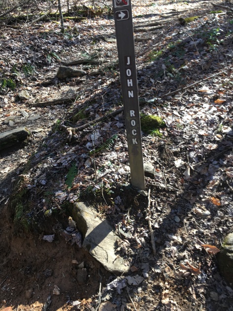
Soon, you will arrive at a sign that helpfully warns you to leash your dogs, children and husbands to prevent them form running off a cliff face. After this, watch for a series of at least three unmarked but obvious paths which lead to the rock. All lead to the same place, but the sloped rock face is often wet and dangerous to access from the trail. On this day, the first and lowest (also the most shaded) was the sketchiest. Sylvia and I walked to the topmost, which leaves from behind an old tree, and work our way downward. This turned out to be far more accessible. Just watch yourself on the wet areas that tend the develop around the shaded spots adjacent to the weeds and bushes, and avoid any inclined sections that damp (especially those covered in fallen leaves or pine needles) and you will be fine.

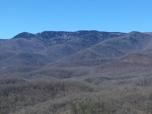
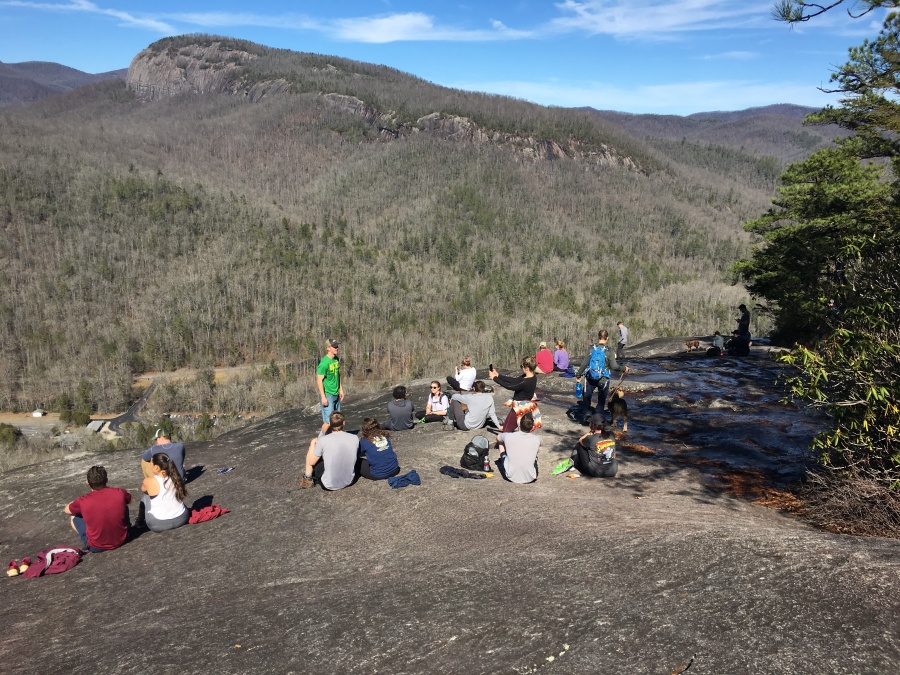
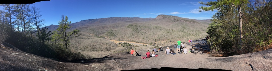
We made our way out onto a wide, impressive slab of rock and least a hundred yards wide, with a panoramic view of the valley and fish hatchery below…in the near distance was a very fine profile view of majestic Looking Glass Rock, one of the most iconic landmarks of North Carolina, and beyond it the main arm of the Blue Ridge, and atop it the Parkway.
One of the most interesting aspects of this view is the plethora of near vertical rock ledges visible straight across the valley. You don’t see this from any of the overlooks at looking glass rock, and I am guessing that even approaching these tricky looking granite faces is dangerous. Peregrine falcons are known to nest here.

We did NOT have the place to ourselves. ☹ In fact, the place was an almost non stop series of groups arriving, taking selfies and departing. As soon as one group left, another showed up.
Securing a nice perch as another couple left, we ate a snack and took some pictures. Even as we sat, a woman arrived and promptly slipped on a wet patch and fell to the rock. She was unhurt, and I counseled her to try the somewhat more exposed but much drier patch to her left. Her companion (maybe her husband) continued on his way, apparently unimpressed with this wanting display of rock hopping.

One notable scene I witnessed before leaving – a couple were sitting with a dog, one of many canines on the summit. As the man was ambling around, he approached close to the edge of the cliff, and the dog went beeserk out of concern for its owner, thinking (not unreasonably) that the man was endangering himself. The dog refused to be consoled until the owner had returned to his side, whereupon the befuddled man was showered by the love and affection – the dog effectively rewarding the master with its unconditional love for his good behavior. The incredible loyalty of dogs to their owners, and their keen sense for danger and trouble, never ceases to amaze me.
We could have continued on along the John Rock Trail and made a loop back to the Cat Gap Trail, but we decided to simply backtrack. The downhill journey was uneventful. We returned to find the lot was now overflowing…cars parked everywhere, along curbs and up on the grass. Hundreds must have made the trip to the rock that day.
*The postscript to the successful hike is that we returned to our campsite to find that some bunch of idiots had stolen one of our camp chairs right from our campsite. Neither of our chairs was new, but they basically stole the newest one and left us the crappier one. There is no limit to the pathetic depths of human depravity, is there? I should know this by now. Who steals a crappy old camp chair, really? Good luck to them. Well, we needed a new one anyway. Move on.
All in all, Sylvia and I very much enjoyed the John Rock Hike. We both consider Looking Glass Rock to be superior, but still John Rock is well worth doing especially if you happen to be staying at Davidson River Campground or in Brevard (though do watch your camp chairs.) There is only one view from the trail but it’s a good one, and if you have a full day, considering doing the Cat Gap Trail as well. We would advise doing this on a weekday or else get a very early start, as it is likely to be crowded. We would definitely NOT approach these ledges in icy conditions. Since there will be no views on a rainy day anyway, there is no point tempting the slabs under inclement weather. Wait for a sunny day.
Sylvia and I both pronounce the John Rock trail as one of the Best Hikes in the Southern Appalachians, fit for any reasonably active hiker with no serious challenges, as long as one exercises caution on the slabs. I don’t know who you are, John, but your rock is cool, and the John Rock Trail rocks!
