Part I: Table Rock, Linville Gorge Wilderness, NC
*We have added Table Rock to to our list of Best Hikes in The Southern Appalachians and Carolinas…and with a serious exclamation point! In fact, we think the Linville Gorge, and particularly the trails off the mostly unpaved Table Rock Road, are hands down the best in North Carolina. The views here are absolutely jaw dropping. We just can’t say enough about the hiking here!
We have long been putting off a trip to North Carolina’s Linville Gorge. Too long, in fact, and so last weekend we decided to do something about it.

Linville Gorge is a 1400-foot deep slot in the landscape through mountainous terrain, at the bottom of which runs the Linville River. It is an exceptionally rugged place by eastern standards; the impressive cliffs and steep walls of the gorge not only prevented its being settled, but also effectively barred any large-scale logging from taking place there, and made road building on its floor all but impossible. To this day it remains almost unspoiled virgin forest, one of the few places where can go and see the landscape in a state much the same the Native Americans did, centuries ago. Even the title of the place is rugged…it takes its name from a pair of explorers who were scalped here by the Shawnee Indians in the 1700’s.
Scalping is not much of a danger here nowadays, but it remains a remote and rugged place. Logistics of a day trip here are complicated, and that’s the main reason why it’s stayed on our to-do list so long. In fact, as recently as a decade ago, you might easily have gone there on any day of the week and seen almost no one else. But the rise of the internet, the omnipresence of mobile devices and the proliferation of hiking sites (yes, like this one) have insured that the word is very much out. But it is STILL quite remote, and compared to other hiking spots with easily accessible trail heads like Looking Glass Rock or anywhere in the Great Smoky Mountains, this is still a relatively uncrowded place.
Most people know Linville Falls, if at all, from the popular stop along the Blue Ridge Parkway where, on any given day, throngs mob to a viewpoint to catch a glimpse of scenic Linville Falls. Somewhat fewer have ventured out from the parkway to the lookout known as Wiseman’s View, where a view down the gorge is afforded. Few ever go any further than that.

We were intent to go further. So early on a Saturday morning, we tossed out backpacks in the jeep and headed west on I-40, striking for this much heralded and overdue spot. I estimated it would take some four hours to reach it. It was mid-April and I was crossing my fingers that the crowds would not be TOO bad this early in the year. After all, the road accessing the trail had only been open a couple weeks.
Our goal this day: Hike Table Rock Mountain and, if time allowed, hike to the rock formations known as the Chimneys which are accessible from the same parking area. Both are along sections of the ubiquitous Mountains to Sea Trail.
By the time we had reached Greensboro we hit very overcast skies. I began to worry that maybe our views of the gorge would be obscured, as is too oft the case in the Southern Appalachians. But we soldiered on…you never can tell what the mountains are going to throw at you.
It took more than four hours as it turned out, but that’s partially because the directions we followed assumed we were coming from Asheville (a quicker approach is possible.) We also got ‘misplaced’ a couple times. Finding the road is not exactly easy…it’s near the little township of Linville Falls, not far from the Blue Ridge Parkway and Morganton, NC.
I won’t provide directions to the site…you’re on your own in that respect. Places like Table Rock should remain as remote and pristine as possible for as long as possible, and while the cat may be out of the bag, I have no wish to drag this cat kicking and screaming onto my own site. The directions, at any rate, can be easily found. Here for example. And here. Go find your way there same as we did, it’s part of the adventure.
I will state that finding the road is not that hard, either, if you have a good set of directions and keep a sharp lookout for the signs; that the road itself is mostly unpaved; that while the dirt section is long (7 miles) and bumpy, most two wheel vehicles can probably do this without difficulty assuming it is dry; that Brian had no issues at all driving his Jeep Cherokee in; and that if the road were wet, I’d think twice about it unless I had four wheel drive.
Many trail descriptions fail to note that the last mile plus of the road (which is quite steep) is also paved, so don’t be surprised by that. One other thing to point out is there is a store with a gas station a couple miles up the highway toward Linville Falls, if you arrive with a dry tank. The forest service road is not a good place to run out of gas.
Arriving at the Table Rock picnic area we found no asphalt spots left in the small parking lot, but a makeshift grassy area was pressed into use. We were soon on the trail and hiking. The sign promised Table Rock summit ahead just one mile. And looking through the trees one could easily see the promise would be kept. The massive head of Table Rock Mountain (3940 feet) loomed close.
Table Rock, and the even more distinctive Hawksbill Mountain, are the two familiar and very odd shaped mountains that one can see for many miles in western NC…they can easily be seen from I-40 near the Morganton/Marion areas, and I have spied them from atop Mt. Mitchell as well.
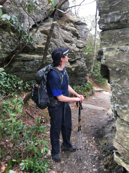
The trail, which is fairly easy until it reaches the rock scrambles at the summit, follows the MST for most of the way. There are partially open views from ledges and very impressive rock formations the whole way. In fact, this hike would be worth it even if the summit was not impressive.

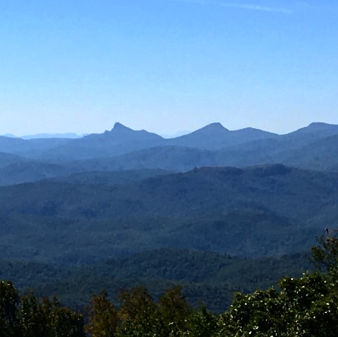
And believe me, it IS impressive. In fact, the views from this series of rocky ledges is the best I have seen anywhere in NC. It’s almost RIDICULOUSLY good! It’s also remarkably pristine. You can look out right into the gorge, whose impressive cliffs rise up opposite, and see nothing man made save a single dirt road. And to the south, over the Catawba Valley, is an almost equally unspoiled view…I-40 and the populated belt is out there somewhere but you can’t see it. All you can see is wilderness for miles. Even farms and cabins are scarce.

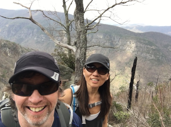
Sylvia and I climbed way out to the very end of the ledges to get a private spot. There’s plenty of those here. The wind picked up, we held onto our hats and had lunch. And took pictures. And stared in awe.
Visible here was impressive Hawksbill Mountain, and the Chimneys which we would hike later. Further on was Shortoff Mountain and Bear Den Mountain.

To the East you could see Lake James in the distance, and to the South, the ridge line of the Black Mountains, which includes Mitchell, the east’s highest point. Back the other way, North, a glimpse of dignified Grandfather Mountain could be had.


And we could even see Linville Falls.
It’s an astonishing place.
Many trail descriptions state that the summit is quite safe, and that’s not inaccurate. It’s quite safe as long as you don’t fall off. ?. The ledges themselves are not particularly difficult but do require some scrambling to get to the best ones. Also note that this is NOT a good place to be in a thunderstorm. One can retire to tree line very quickly from the summit, and if a storm moves in, I would strongly advise doing that.

After lingering on the summit for a while and just marveling, we decided it was time to go and explore the Chimneys. We could see it looming in the distance and thought it might be interesting. We weren’t wrong. But that is another post.
Next: Two Miles of Wow, Part II…The Chimneys