The Gregory Ridge Trail, Great Smoky Mountain National Park
*One of the Best Hikes in the Great Smoky Mountains is the Gregory Ridge Trail
**We have added Gregory Bald to our list of the Best Hikes in the Southern Appalachians. It’s a fine trail well worth doing IF you can make the logistics work…this is one trail where getting there and avoiding traffic jams en-route may be in some ways more difficult than the trail itself.
For many years now I have been wanting to hike the Gregory Ridge Trail to see the open meadows atop the mountain of the same name. For many southern hikers, this is the finest trail in GSMNP, and the 10 acre patch near the summit THE view in the park. Especially in June when the mountain azaleas are blooming
The reigning online authority on Smoky Mountain Hiking is the excellent (and aptly named) hikinginthesmokys.com…they rate Gregory Bald as the #1 hike in the entire park, above Mt. Cammerer (which was my own favorite going into this) Charlie’s Bunion, Andrews Bald, the Chimney Tops, and any trail to the top of popular Mt. Leconte. High praise indeed.
Sylvia and I are preparing for the Tour De Mont Blanc in July, and in need of some big hikes fast, so we weren’t willing to wait for June and the azalea bloom. But even if we were, we’d likely pass on it. Hiking the Southern Appalachians is best done between Labor Day and Memorial Day…we typically avoid the summer dog days and the heat, bugs, haze and crowds that go with them. And at any rate I’m not much of a flower guy.
As I have stated previously, the key to hiking the vastly over-visited Smokies is:
- Avoiding the throngs in Gatlinburg (and the East side casino town of Cherokee)
- Securing a campsite/accommodations
- Beating the heat
All the following can be accomplished by simply visiting during off-season, on a weekday if possible. In the case of Gregory Bald we had an added challenge…the trail head is located on the far side of the Cades Cove auto loop. For those who are not acquainted with Cades Cove, it is…
- Probably the signature attraction of GSMNP (besides maybe bears)
- One of the most stunningly beautiful mountain valleys in the entire Eastern United States
- Accessed by a 20-mph site seeing road, slow at the best of times
- At the worst of time, a nightmarish traffic jam
In addition to all the above, the trail head is at LEAST a 90 minute drive from Gatlinburg. In peak season summer traffic conditions it could be twice that far. And both the campground in this area of the park – Cades Cove and Elkmont – are popular crowded in peak season.
What all this means is, if you have an opportunity to do this off season, seize it when you can. This trail is not nearly as popular as the Alum Cave Trail or Charlie’s bunion so…if you go off-peak, you might even have it almost to yourself. And you may get lucky and have good weather as well.
And that is exactly what we were hoping for.
We left for the smokies on a Thursday morning in mid-march, planning to stage out of Cades Cove campground, which at that time of year is almost deserted. The plan worked out well, for we arrived in a near empty campground just after 5 pm (the drive took us nearly 7 hours.) The only down note was that the camp store had closed, and we really wanted a fire on this cold night. Fortunately, there is a self-service station that sells firewood after hours. The park service employees who were closing up the store were kind enough to let us inside to make change…great help there. These guys deserve a better boss than this guy. But I digress.
After a cold night (both times I have stayed in Cades Cove, it has been brutally cold) we departed the next morning for the trailhead, which ended up being another 30 minutes up the road. Do NOT underestimate the traffic conditions on the loop road, you will be behind cars full of sightseers the whole way. 10 mph is the best you can hope to average, and that with frequent stops.
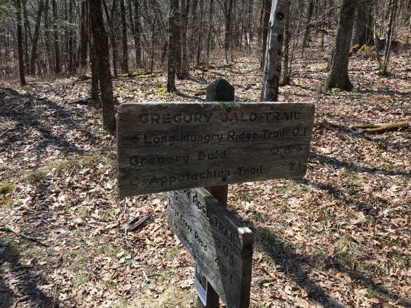
We found the trailhead easily enough down the Forge Creek Road, a gravel road which departs from the main loop road just past the visitor center. The road is entirely passable to any vehicle. Note that there is another, shorter trail to the Bald off Parsons Branch Road, which diverges from the Forge Creek road just before the main trailhead. This road was closed for the winter, so it was not an option even if we had wanted to hazard it (yes, the Parson Branch Road is quite sketchy. More on that later.)
The trailhead parking area is surprisingly small, perhaps a dozen vehicles could fit. I can only imagine the scene in peak season…when we arrived, only three or four vehciles were already in residence. And the day promised to be clearing. It seemed we had an answer to both out wishes. But to still had 5.5 miles of trail between us and Gregory Bald…we needed to get cracking.
The trail starts climbing hard right out of the parking area, but this is just a temporary state of affairs. It soon returns to river level and proceeds nearly level for a half mile or so before turning uphill. Then, it proceeds at a steady pace upward along a moderate grade…and this in a nutshell is the story of this trail. It is really nowhere steep, but it never lets up on the climb, either.
The lower sections runs near a stream with fine cascades, crossing it twice on the standard cut-log-with-crude-handrail bridges. The second of these bridges is leaning rather precariously, but neither presents a serious challenge. As often happens with sections of trails following watercourses, this part is muddy, and there are some brief areas where the trail seems to be routed through creek beds, or else creeks have re-routed themselves over the trail. None of these present a serious obstacle, though.
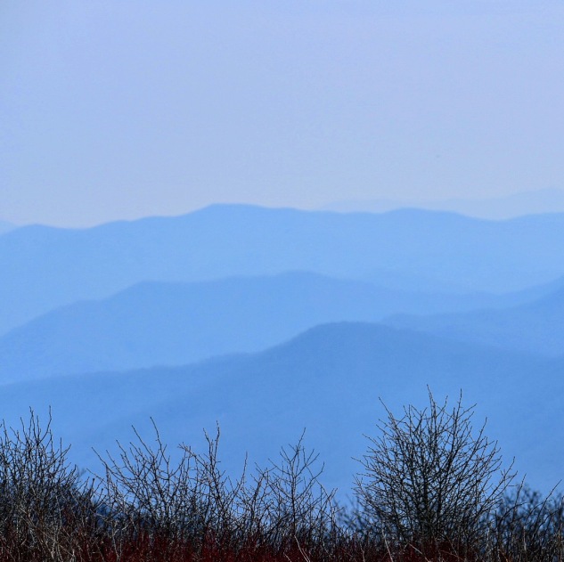
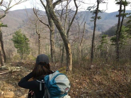
After the second bridge, where there is a really nice small waterfall, the trail passes a backcountry campsite. From here on it goes up hill at a steadier pace, almost without switchbacks, rising slowly but with no letup along the side of a ridge. This section is a bit less waterlogged and soon, the first viewpoints appear on the left. As it climbs higher, partial viewpoints begin to appear on BOTH sides of the ridge…note this is another reason to hike this trail during leaf-off, in summer you might not see anything but the Long Green Tunnel.
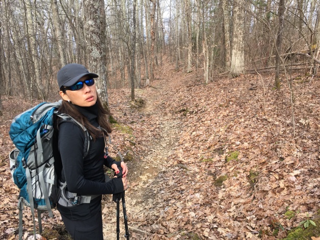
Sylvia, walking in front of me, had a few run ins with fallen branches, several times getting her feet tied up and once executing a slow-motion pratfall. (She was thankfully unhurt.) Being early in the season there was a lot of uncleared debris on the trail…we tried our best as we went to be our own trail crew, clearing what odd debris we could.
Maybe a little over halfway the first patch of snow appeared. There would be many more above this, and some areas where snow covered entire ridge lines, but for the most part the trail itself was clear. We did have one rather dicey traverse of a very narrow section of trail along a steep, wooded slope that the snow melt had turn to a mucky stew that seemed dangerously close to washing out…but thankfully, this section was quite brief.
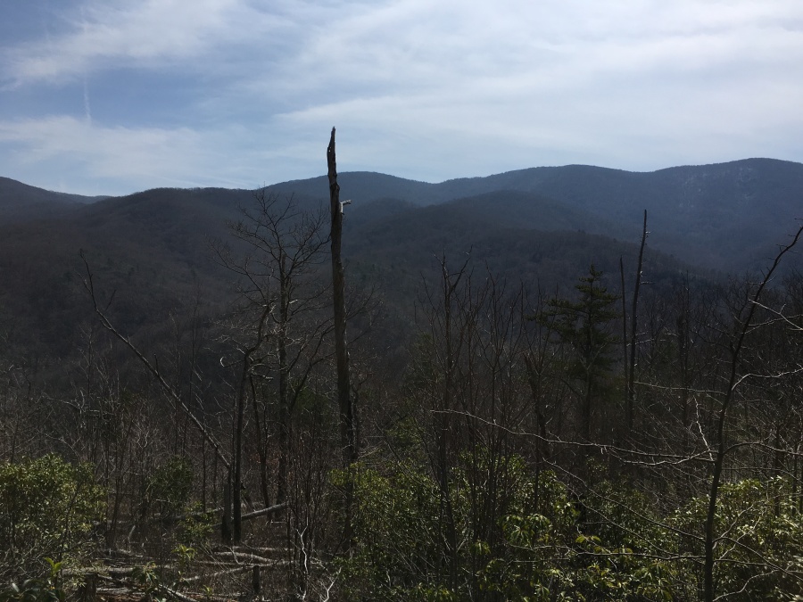
On and on the trail continued to rise, always seeming to break right around one similar looking wooded hump after another. At times a tantalizing view of the bald will appear through the trees, always looking depressingly far away. This is one of those trails that just seems to go on FOREVER. Though it is no greater in distance than the Alum Cave or Mt. Cammerer hikes, it feels longer. This may be because of the way the trail rises slowly but continuously, or it may be due to the lack of really notable features along to way to break up the monotony. Not sure but…anyway, five miles and change one way is a good hike any way you do it.
Not long after the sludgy-snowy section we finally arrived at the junction we had been looking for the whole afternoon, where the Gregory Bald Trail intersects the Gregory Ridge Trail. From here one can hike left about two miles to reach the Appalachian Traill…and in fact, in times past the AT did in fact run across this very same stretch of trail and over Gregory Bald. But it’s long since been re-routed. At any rate, our business was to the right…the last half mile of trail between us and the much anticipated views of Gregory Bald.
There are two somewhat steep sections along this last half mile, one near the junction and one nearer the top (just after a sign that helpfully states not to transport horses beyond this point.) These amount to the only really steep sections of trail along this whole route, such as there is. In fact, many long sections of the Mt. Cammerer Trail are much steeper even than these, so as far as trails go, the entire length of the Gregory Ridge Trail is a fairly modest grade by my reckoning. There’s nothing here that the knees will really take exception to.
Past this last steep push the trail diverges where unmarked paths head left and right (there are no blazes that we saw along this trail but its nonetheless very easily followed.) The left goes into some shrubs while the rightward and lower path breaks right out of the trees and into the clear. Views beckoned; we chose right.
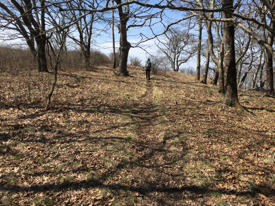
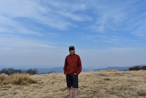
Immediately, the hiker is rewarded with fine open vistas over the treetops all the way to the nearby mountains. As one traverses the meadow, angling upwards toward the summit, Cades Cove comes into view, quite distant, a reminder that the hiker is deep inside one of the largest pristine wilderness areas in the US. GSMNP may be heavily visited, but most visitors never see more than 5% of it at most.
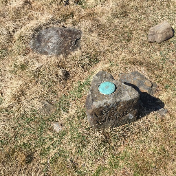
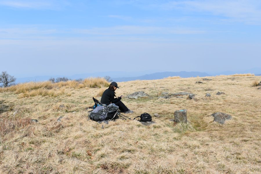
We angled uphill past a relaxing couple who had past us earlier on the trail, and quickly found the summit. There are some rocks and a small pedestal with a US Geological Survey Marker on it. The summit doesn’t feel like a mountaintop…it feels more like a field. And in fact it is a sort of cultivated field…the NPS keeps it open deliberately to preserve it as a bald. Otherwise, it would have long ago grown in. Like most other grassy balds in the south this is not a naturally open summit…fire or some other natural event long ago cleared the mountaintop of trees, and nature tries continually to reclaim it.
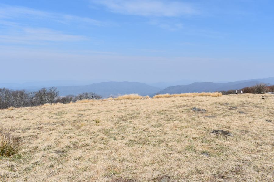
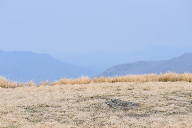
Despite this it’s still a fine place to sit, have a snack, and just gaze. There are views in all directions. Some mountains we’ve visited before are visible. In the distance for example was Mt. Leconte.
The top of Gregory Bald is not ENTIRELY open. In additional to the shrubs which bloom in summer, there are clumps of trees too, and these afford the hiker some shelter from the wind.
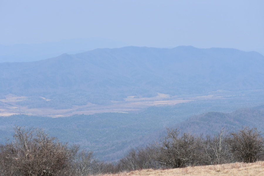
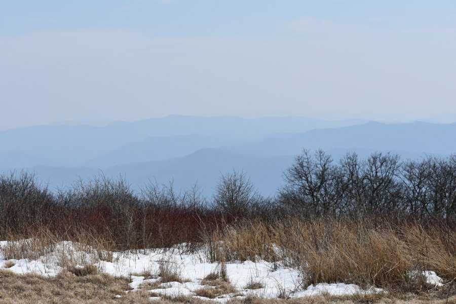
The weather was fine. The previous day had been quite windy (this one less so) and this had led us to hope that the haze which often obscures the long-range vistas in the Smokies might have been blown away…much like what happened to us on Sharp Top in Virginia a couple weeks earlier. But this was not to be. While I have seen hazier days, the air quality today was not pristine, and the mountains and ridges in the distance were mostly ghostly shadows.
Oh! I almost forgot that this hike was also done to celebrate my birthday. I had become a ‘man of a certain age’ that begins with a crooked number earlier that week. I tried out my new birthday present, a great Nikon camera given to me by one of my favorite photo subjects…this one. It was awesome. Many of these pictures were taken with it.
We stayed as long as we dared. Once late afternoon set in we had to be going, for we estimated it would take at least two and a half hours to get back down, and we wanted to return to camp before dark.
We were close to the mark. The uneventful descent took two hours and forty minutes. On the way, we passed an intrepid couple obviously intent on camping on or near the summit to enjoy the sunset/sunrise. It rained that night, so I hope they enjoyed at least one of the two. We were the last people off the mountain that day.
All in all we very much enjoyed Gregory Bald, which was a great long distance day hike to shake out for bigger things to come. This was a marathon slog…exactly what we needed! We loved the very well maintained trail itself…I thought it the best I had hiked in years…and would strongly recommend doing it in leaf off.
Sylvia and I were a bit disappointed in the summit itself. It’s a nice meadow with fine views, but not the best that I have seen. Most of the southern balds have in fact disappointed me. They don’t have the same wild character that I remember from my days hiking in the Alpine wilderness of the White Mountains up north…and virtually any rocky topped peak looks and feels more like a mountain. And then there’s that darned haze in the air…admittedly, not all of this is pollution, some is just naturally occurring. They don’t call this the Smokies for no reason. Still…the views are simply not what they could be.
It is still our opinion that, all things considered, Mt. Cammerer is both the more challenging and more scenic hike, though it has a much smaller open summit and fewer views from the trail itself. I might be tempted to change my mind if I did Gregory Bald on a clearer day but…my opinion for now stands: Mt. Cammerer is still the undisputed champion of the Smokies.
We would recommend the Gregory Ridge Trail to any fit hiker. The trail itself is no difficulty, except for a little mud; there is little danger of exposure despite the open areas, if common sense is exercised; and there are only two short steep sections, and no difficult water crossings. It is however a LONG day hike. A novice hiker might well find this a depressing experience. I would suggest doing Charlie’s Bunion or the Jump Off or the Rich Mountain Loop first before tackling this one.
Also, leave plenty of time to do this, especially on a fall or winter day when daylight is scarce. Give yourself at least an hour, preferably two, to drive here from Gatlinburg (or camp at Cades Cove as we did.) And remember that if you linger on the top and arrive back at your car at sundown, you will have a lengthy drive out over dark and winding mountain roads ahead of you. Prepare accordingly.
Note that there is an alternative approach trail (the other side of the Gregory Bald Trail) that leaves from the Parsons Branch Road and is shorter. It is, however, steeper; and many accounts of the Parson Branch Road fail to note that this ‘road’ is basically a jeep track, which is one way and takes you many miles away from where you started. Unless you have a 4WD vehicle and are confident off-roading, we do NOT recommend this approach. At any rate, much of the year this road is closed.
Our advice is come prepared, leave yourself plenty of time, and do this out of peak season…and hope you get a window of good weather so you can enjoy Gregory Bald, high upon the roof of the Smokies!