Pilot Mountain
*We have added Pilot Mountain to our list of the Best Hikes in the Carolinas.
If you have ever been to the fine City of Winston-Salem, NC or traveled on US Route 52 near the Mt. Airy area, then you can’t have missed Pilot Mountain, one of the most distinctive landmarks of the Carolinas. It is also visible from the Blue Ridge Parkway.
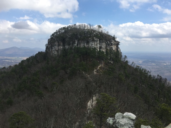
Pilot Mountain at 2,421 feet is not technically part of the Appalachian Mountains, though it is close to the Blue Ridge. It is rather a part of the old remnant Sauratown Mountains (whose hilly crags and ridges also include another of our favorite regional destinations, Hanging Rock State Park.) It’s also a Monadnock. People from New Hampshire will understand this immediately.
https://en.wikipedia.org/wiki/Inselberg
Though we have seen it many times from the road we have never hiked it – until now. We decided to include it in our preparations for the Tour du Mont Blanc this summer.
Getting to the trail is easy. Located two hours from Raleigh (and just 10 minutes from Winston Salem) all you need to do is follow the highway to the Pilot Mountain State Park exit, get off and enter the park, find the parking area, and then cross your fingers and hope you get lucky enough to find a parking space. An early start or mid-week visit helps a lot.
Despite a somewhat late start on a February weekend, we DID manage to get lucky. We got there just as someone else was leaving and got the closest spot to the trail in the tiny first parking area along the road. ?
Note that down the road there is another overflow parking area, but this one is without a restroom. Parking at this one however does shave a couple hundred yards off the hike. Also note there is another parking area MUCH closer to the action…but more on that shortly.
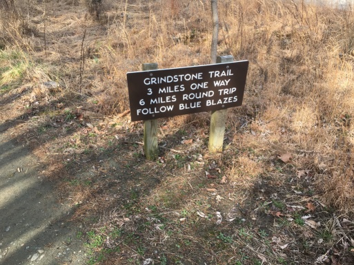
A sign for the Grindstone Trail (6 miles to the top) is just across the road from the parking lot. Though one might think the name ominous, in fact the Grindstone Trail is more like a well-smoothed chunk of pumice. It is one of the easier trails I have ever hiked.
After passing the overflow parking where we got turned about for a bit (the trail again crosses the road) the uphill starts in earnest. The Grindstone Trail along this section follows the Mountains to Sea Trail, which we seem to encounter everywhere we go in this state (including right by our house.)
The Grindstone Trail then goes up and down for a bit. Some interesting boulders are passed along this section, but they are easily surpassed by the ledges you’ll see later. My advice here is, wait and snap a picture on the way down…if you are still interested.

The trail passes the campground for Pilot Mountain State Park and crosses some dirt roads. In fact, sections of the trail itself seem to be a dirt road. It’s a pleasant walk but often the lacks the feel of a real hiking trail. A couple of good things about it were that it was nearly devoid of people (along this section) and a couple can walk side by side, as we did.

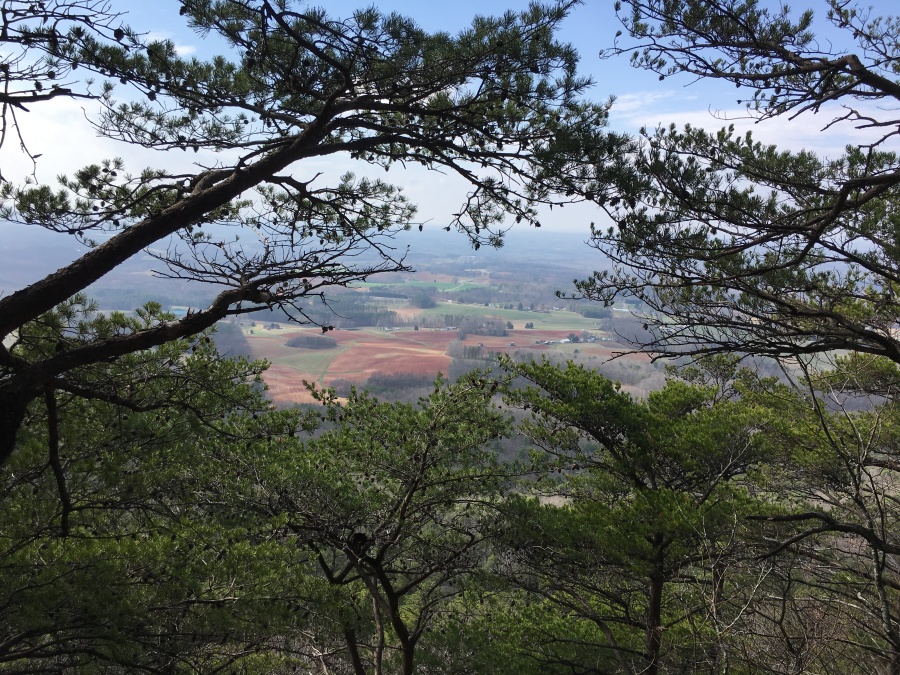
At the top of the first serious uphill the MST diverges and the Grindstone trail breaks for the summit. Here is a fairly gentle ridge walk. Some partial views were had along this section, but we hiked in winter. When the leaves are on, our bet is you won’t see anything but green.
Soon you will cross an intersection with the Jomeokee Trail (The Mountains name to local Native Americans was Jomeokee, meaning “Great Guide.”) Soon after it breaks sharp left where there are some views off a ledge to the flatlands below. From here the trail makes a sharp climb often using well placed wooden steps…the step ups/downs are high, but neither Sylvia or I had any issues with the sections, except that Sylvia chastised some young people who were hiking too fast. The footing is uniformly good.
The trail reaches its first grand vista where an obvious rock slab picnic area comes in on the right. The main trail continues left to the summit, but a much cooler herd path follows the slabs. There was a huge group on the picnic ledge (and some rock climbers as well) so we continued on further and found an even BETTER view point.
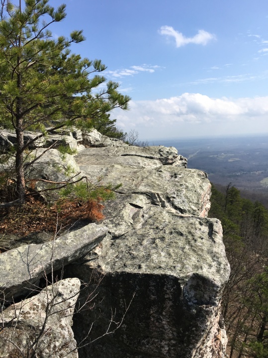
Note there are many great views to be had in this area, but technically speaking its supposed to be for rock climbers only. Treat the area with respect, be mindful of the climbers (who may have anchored ropes in the rock) and just exercise caution. The slabs are generally safe. Compared to slippery John Rock, which we had visited the week before, these were no problem at all.
If this area seems crowded, its because most people start their hike near here…at the top. That’s right…atop Pilot Mountain is a parking lot. ?
For those not interested in hiking all the way you can simply park and join the throngs on the top. Assuming you can find a spot. But there is no reason to be in a hurry to do so…the trail up is a nice walk and is quite moderate. Of course, once you reach the top, joining the throngs is mandatory. You will have little choice.
The throngs are thickest around the Little Pinnacle Viewpoint, where there is a view of Big Pinnacle, which gives Pilot Mountain its distinctive shape. People are not allowed up there, by the way…you can hike out to the cliffs but not to the very top. Note the crags of Hanging Rock State Park visible behind it.
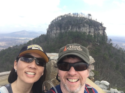
We needed to elbow our way in to position for a photo, into a crowd of people posing for one selfie after another after another. After another.
I have often noticed that if one can drive to a great viewpoint, and thus spend nearly no effort getting there, then the people found there will inevitably be MANY times more likely to hog the viewpoint all to themselves. My least favorite example was a fool we saw last year who had strung a hammock across a really nice (and well visited) viewpoint on Waterrock Knob on the BRP. A thing easily done becomes devalued. Most who hike to a great view understand its value and thus are respectful of others. This is one of about 17 reasons why I prefer to hike WELL away from the herd, and generally stay far from drive up summits if I can.
We didn’t stay long on the summit. After taking our obligatory photo of the Pinnacle we packed up and headed down. The trip down was pleasant, uneventful and uncrowded. It took us just three hours, total, to do the whole thing…including our stay at the top.
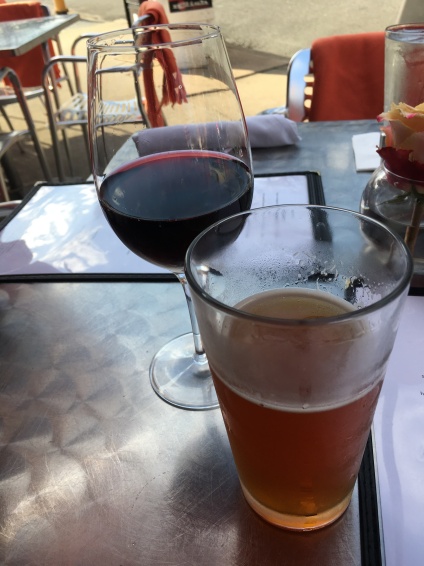
As we had forgot to bring snacks, so we were famished. Required was a stop in an excellent Bistro in Old Town Salem for late lunch. Despite being February it was about 70 degrees, and so we sat outside. It was a great ending to the day.
All in all, we enjoyed the Pilot Mountain Hike via the Grindstone Trail, but I would not call it one of my favorite hikes. The crowds at the top definitely detract from the experience, though the views are fine. The trail is easy by our standards, lacking much of a true challenge, and not all of it was scenic. We think neighboring Hanging Rock State Park is better…there is more and better hiking and, though it too can be crowded, no parking on any of its summits. I would recommend this hike to anyone living in the region, but there are much better hikes to the east and west of here. Try Hanging Rock. Or Stone Mountain. Or Virginia’s Peaks of Otter…
…Hhmmmm…that last one might not be a bad idea!