Through the Looking Glass: Looking Glass Rock
***SUMMER RE-RUNS: Brian and Sylvia are currently off having new adventures. In the meantime, please enjoy this re-post from Spring 2018***
* Looking Glass Rock is one of Becauseitzthere’s Top Ten Hikes in the Southern Appalachians V 1.0. It is also a featured Best Hike Near Asheville (it is less than an hour away.) See our hikes page!*
Having posted about John Rock, I though it only fitting to go back to the archives and get together a post about another best hike in the Brevard/Asheville area…Looking Glass Rock. This one is actually even BETTER than John Rock. Sylvia and I had the pleasure of doing on an autumn day a few years past.
If you chance to drive down the Blue Ridge Parkway near the Mt. Pisgah area, you almost can’t miss Looking Glass Rock (unless the weather is awful.) It’s the big dome shaped megalith visible for many miles along the parkway, looking south. The cliffs that face the parkway are so sheer it reminds many of a mirror…a looking glass, in other words.
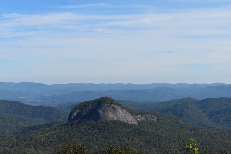
The rock face itself can be climbed by those intrepid, skilled and equipped enough to do so. But it can also be hiked…to a view point on very top of the rock slab. It’s one of the best singular views in the region.
The Trail is accessed via a small side road off US Route 276, AKA the Forest Heritage Scenic Byway., about 15 minutes North of Brevard, NC. Look for the sign for the State Fish Hatchery and Pisgah Center for Wildlife Education. The trail head is about a half mile down this road on the right; it is almost impossible to miss it. There is a small pull-in where a few cars can park, and usually there are a few in residence, because this is a popular trail. In fact, if you do this on a peak weekend, cars will be lined up down both sides of this road for hundreds of yards.
If you do find yourself at the parking area for the wildlife center, turn around…you’ve gone too far.

Once out of the parking lot the trail begins immediately climbing out of the narrow valley which is home to a tributary of the Davidson River. The climb is steep through most of the early and middle sections, though nowhere unusually so. It rises through pleasant and open woods, eventually reaching the first of several switchbacks where it begins to zigzag back and forth.
When we did this a few years back it was late October, past peak for fall colors. But some were still in evidence.

There is a partial view from a blow-down patch at one of the bends, though it has mostly grown back in. Somewhere near here, back in 2008 I believe, a black snake threatened me when I came upon it lying in the trail during high summer. I have since learned to confine my hikes to spring and fall in the south.
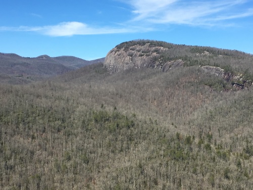
As the trail nears the top it levels somewhat and some slabs appear, which are a harbinger of things to come. Some of these offer partial viewpoints, but none are as good as the main one. A few of these herd paths also lead to bootleg campsites and popular routes used by rock climbers.

You will also pass an open clearing used as a helipad for rescue operations. Rock climbing has its risks; a $10,000 helicopter ride is not the least of them.
The true summit of Looking Grass Rock is about three miles from the trail head…a sort of hump that is almost completely treed in. There are a few side trails leading off to tantalizing viewpoints, but these are only sideshows to the real event. Continue down the trail another 100 yards for the million dollar view. Note that the trail actually goes DOWN hill this last bit and the trail bed is somewhat rough along the way…this confuses many hikers.
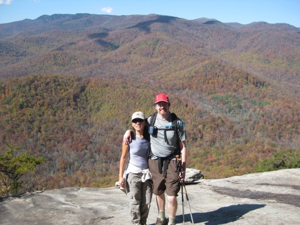
But at the end the trails breaks sharply left down a rocky bit and out onto an expansively open ledge. It’s really the only easily reachable view along this trail, but it is an impressive one.

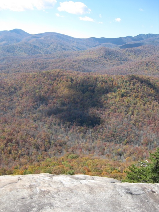
The slabs at the top of the cliff are HUGE, much bigger than the slabs of John Rock away across the valley. These clifftops generally get good exposure to the sun, which helps to dry them out; but there are bound to be wet patches, too. Both times I have been there, it has been mostly bone dry.
Do NOT get too close to the edge here. The pitch of the slope is fairly extreme, making it difficult to tell how close to the vertical part of the cliff you really are. Don’t over-confidently walk out too far on the steeply angled areas. If you have a dog, restrain it. If you have children, keep your eye one them at all times. A mistake here would have serious consequences.

The grand 180 degree view takes in the Blue Ridge, including Sam’s Knob, the Black Balsams and Pilot Mountain, some of the best hiking peaks in NC. Views of ubiquitous Mt. Pisgah and Cold Mountain are blocked by this ridge, but they’re close, too.
Also visible are sections of the Blue Ridge Parkway. In fact, look closely and you may notice the glint of windshields parked in scenic pull offs at eye level or higher on the opposing ridge. Bring a binoculars, you may see some people looking back at you!
Also potentially visible here are Peregrine Falcon which nest on the cliffs. For this reason, parts of the cliff are sometimes closed, though I have not recently seen any trail closures. Checked with the National Forest Service website before hiking to be sure. I haven’t personally seen a falcon here; I did see one on Angels Landing in Zion National Park but…that’s another blog post.

Looking Glass Rock is a GREAT place to sit, have lunch and merely gawk. Because the rock is so big it tends to thin out the crowds. Both times I was there it was actually not too crowded. It seems to have become more popular lately, for understandable reasons.
The walk down through the forest is always pleasant.

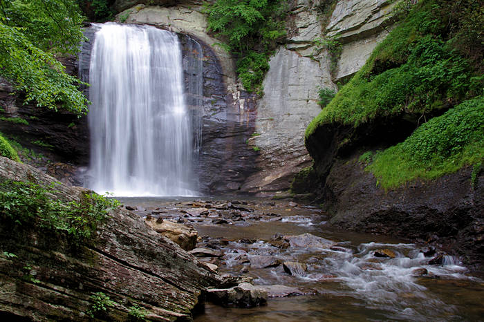
After the hike, be sure to stop at Looking Glass Falls out on US 276. It’s probably the closest good sized waterfall to any road in the Appalachians (just a few feet off the pavement.) Finish your trip off with a stop for a beer or burger in scenic Brevard, perhaps our favorite small North Carolina town!
Looking Glass Rock is one of the best places to hike in North Carolina. We would highly recommend this trail to any reasonably fit person; you don’t even have to be much of a hiker, though the steep early and middle parts of the trail will challenge the unprepared. There is little danger from the cliffs as long as one does not venture too close to them. Exercise caution on the slabs and avoid them in icy conditions altogether. I would save this hike for good, sunny weather, for the outstanding views and to be sure the rock slabs are suitable for walking.
Once you have put this trail under your belt, consider the nearby John Rock Trail, which ascends to another fine viewpoint, this one not quite as good as Looking Glass Rock, but it does have a view OF the cliffs from an unusual angle. And if that is not enough for you, try the Art Loeb Trail or Sam’s Knob.